Map Reading Practice for CritiCall, Firefighter, and Police Exams (Canada)
- Posted by Brian Stocker
- Date September 29, 2020
- Comments 4 comments
Does the map reading section of your upcoming Police Dispatch or Firefighter exam have you feeling lost?
You aren’t alone.
Spatial orientation and map reading questions are among the most intimidating parts of emergency service entrance exams. Why? Because in the real world, a wrong turn means a delayed response; on your exam, it means a lower score. Whether you are preparing for the OACP, RCMP, CritiCall, or a Firefighter aptitude test, this guide cuts through the confusion. We’ll teach you how to spot one-way street traps, calculate travel times instantly, and find the shortest route without second-guessing yourself. Let’s get you navigated toward a passing score.
This guide is for adult candidates preparing for occupational entrance exams in law enforcement and emergency services.
Are you taking the OACP, RCMP, or CritiCall?
You can get our complete Map Reading Mastery training as a standalone course below.
BUT WAIT: If you are preparing for a specific agency exam, this entire map reading module is already included in our Full Prep Courses! Check our [OACP SIGMA], [RCMP], and [CritiCall] packages to get the best value and prepare for every section of the test, not just the maps.
You’re staring at a grid of one-way streets, the clock is ticking, and your career is on the line. Most candidates think map reading is just “common sense”—until they hit the CritiCall Map Reading Test or the OACP Certificate Map Test Prep. In the real world, a wrong turn is a delayed response; on the exam, it’s a failed application.
Already have a study guide but failing the map reading section?
Buy our standalone Map Reading Mastery Course.
Choose your Test

 Canadian Firefighter
The “Google Maps” Trap: Why Spatial Orientation Tests in Canada are High-Failure
If you’ve spent years relying on GPS, your “spatial muscle” has likely atrophied. Our Canadian Police Map Reading Practice doesn’t just show you a map; it installs the “Dispatcher’s Intuition” required to pass on your first try. Let’s stop the guesswork and start navigating toward your new career in Canadian emergency services.
Important Note:
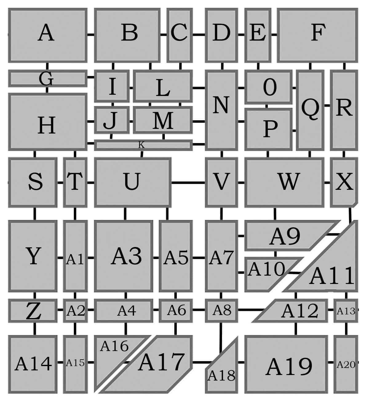
When you go from, say, A to N, Start at the beginning of A, so you traverse A and then arrive at N, so you do not transverse N
Blocks are NOT proportional – 2 small do NOT equal 1 large
Map Key
Each square labeled A to Z and A1 to A20, represent the corner of an intersection. The lines between the squares represent a city block. The intersections and city blocks fall
under 3 categories.
Large blocks: A, B,F, H, N, Q, R, U, W, Y, A3, A5, A7, A9,
A11, A14, A17, A19
Small blocks: C, D, E, I. J, L,M, O, P, S, T, V, X, Z,A1, A4,
A10, Z, A12, A15, A16, A18, A20
Mini blocks: G, K, A2, A6, A8, A13
The time it takes to travel from one city block to another is:
Large blocks
In a car: 4 minutes
On a bike: 6 minutes
On foot: 10 minutes
Small Blocks
In a car: 3 minutes
On a bike: 5 minutes
On foot: 8 minutes
Mini Blocks
In a car: 2 minutes
On a bike: 4 minutes
On foot: 6 minutes
Map Reading Skills
The critical skill on map reading questions is to find the most direct route. Practice identifying the shortest or most direct route between two locations on a map.
Map Questions
1. What is the shortest time it would take a woman to go from block A to S driving a car?
a. 10 minutes
b. 7 and half minutes
c. 8 minutes
d. 13 minutes
2. What is the shortest time it would take a man to go from A to S if he drove the first two blocks, then rode a
bike the rest of the way?
a. 18 minutes
b. 12 minutes
c. 17 minutes
d. 15 minutes
3. A student has to walk home from block U to R. What is the shortest time it would take him if he had to go
through block Q?
a. 34 minutes
b. 32 minutes
c. 37 minutes
d. 29 minutes
Answer Key
1. A
The shortest route would take a car through A – G – H , covering two large blocks, and a mini block. This would take 10 minutes by car. (2 large blocks ( 4+4), and a mini block (+2) = 10)
2. B
The shortest route from A to S is A – G – H, taking 6 minutes by car for the first 2 blocks and then 6 minutes by bike. Total time is 12 minutes.
3. A
The shortest route from U to R passing through Q is U – V – W – Q – R . Time to walk these blocks is 38 minutes.
The “Micro-Challenge”
Mental Exercise: Without looking back at the map legend, what is the travel time for a “Small Block” on foot?
If you said 8 minutes: You have the memory for this.
If you had to scroll up: You will struggle with the Emergency Services Map Questions which require rapid-fire data recall. We can fix that. [Map Reading Course]
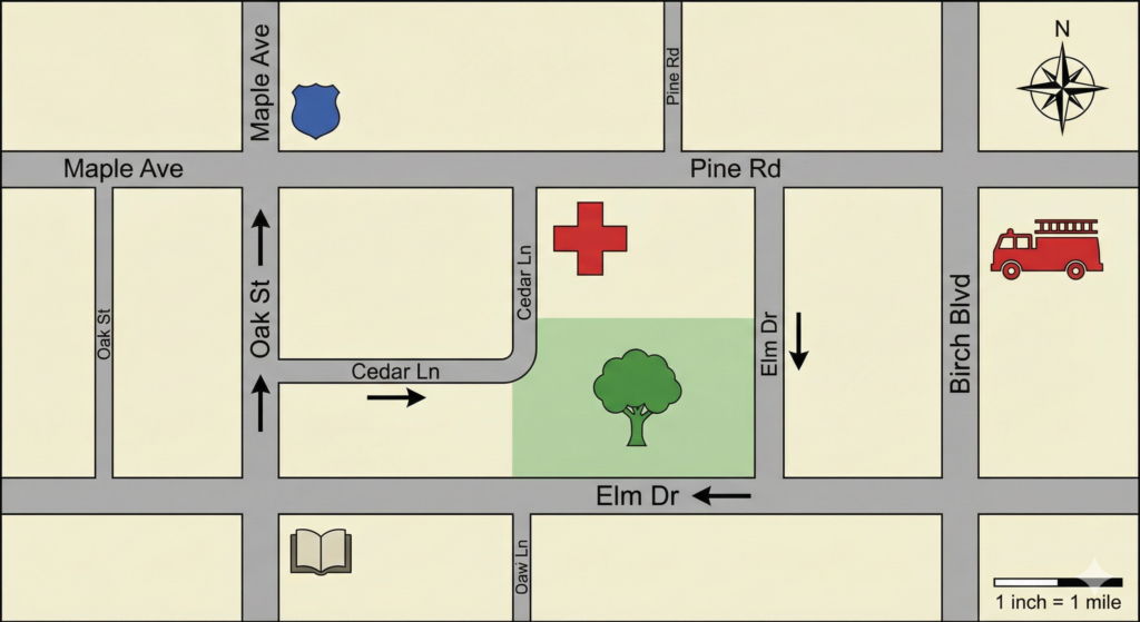
Note on Traffic Rules for this Map:
- Arrows indicate the ONLY direction traffic may flow on that specific section of the road.
- Assume all streets without arrows allow two-way traffic.
- North is up.
1. Logical Navigation & Traffic Laws You are currently parked at the Library (book icon, bottom left). You receive a call to proceed to the Hospital (red cross). Obeying all indicated traffic flows, which of the following is the valid route?
A) Head East on Elm Dr, then turn Left on Elm Dr (vertical section).
B) Head North on Oak St, turn Right on Cedar Ln, and proceed East.
C) Head North on Oak St, turn Right on Maple Ave, then Right on Birch Blvd.
D) Head West on Elm Dr, then make a U-Turn.
2. Relative Location Identify the landmark that is located South of Pine Rd and West of Birch Blvd.
A) The Fire Station
B) The Park
C) The Hospital
D) The Police Station
3. Directional Flow A vehicle is travelling South on the vertical section of Elm Dr (East of the Park). Upon reaching the intersection with the horizontal section of Elm Dr, which compass direction must the vehicle travel to comply with traffic markers?
A) North
B) South
C) East
D) West
4. Following Instructions Start at the Police Station (top left). Drive East on Maple Ave to the next intersection. Turn Right (South) onto Pine Rd (Wait, Pine Rd is parallel, let’s assume the intersection is with a N-S street). Let’s correct the instruction based on the map: Start at the Police Station. Drive East on Maple Ave to the intersection with Birch Blvd. Turn Right (South) onto Birch Blvd. Turn Right (West) onto Pine Rd. Stop at the next intersection. Where are you located?
A) The corner of Pine Rd and Oak St.
B) The corner of Pine Rd and Cedar Ln.
C) The corner of Maple Ave and Oak St.
D) In front of the Fire Station.
Answer Key
1. B
-
Option A is incorrect because the arrow on the bottom section of Elm Dr points West; you cannot travel East.
-
Option B is Correct. Oak St is a one-way street heading North (indicated by the arrow). You can turn Right onto Cedar Ln, which has an arrow pointing East, leading directly to the Hospital entrance.
-
Option C is inefficient and potentially incorrect depending on Birch Blvd’s access, but B is the most direct and clearly legal route.
2. C
-
The Fire Station is North of Pine Rd.
-
The Park is South of the Hospital.
-
The Hospital is clearly situated below (South of) Pine Rd and to the left (West) of Birch Blvd.
3. D
-
The vertical section of Elm Dr has a Southward arrow.
-
The horizontal section of Elm Dr has a Westward arrow.
-
Therefore, when the vehicle turns from the vertical section onto the horizontal section, it must follow the flow of traffic heading West.
4. B
-
Start Top Left (Police Station).
-
Go East on Maple to Birch Blvd (Top Right corner).
-
Turn South on Birch Blvd to Pine Rd.
-
Turn West (Right) on Pine Rd.
-
Proceeding West on Pine Rd, the next intersection you hit is the vertical street connected to the Hospital, which is Cedar Ln (or the extension of it). The intersection is Pine Rd & Cedar Ln.
Already have a study guide but failing the map reading section?
Buy our standalone Map Reading Mastery Course.
Tips for Answering Map Reading Questions
- Read the Question Carefully: Good Advice for any type of question! Understand what the question is asking. Are there specific instructions?
- First, Familiarize Yourself with the Map: Try to get a general sense of the layout and any distinguishing features. Note the scale, legend, and orientation (north arrow).
- Use the Legend: Make sure you understand all the symbols and information.
- Scale is Important! Scale gives the relationship between distance on the map and distance on the ground.
- Take Your Time: Important for any type of test question! Analyze the map and any relevant information before attempting to answer. Don’t speed through but don’t hang around either – work carefully and methodically.
- Eliminate Incorrect Options: Elimination is your best multiple choice strategy. How to answer multiple choice
- Practice Regularly: Nothing beats knowing your stuff! Practice regularly until you feel confident. How to prepare for a test How to Study
- Double-Check Your Answer: Before submitting your answer, review it to ensure accuracy. Look back at the map and the question to confirm that your answer makes sense in context.
Date Published: Tuesday, September 29th, 2020
Created by Brian Stocker and the team in Victoria, BC.
Helping students succeed since 2005
Got a Question? Email me anytime - Brian@test-preparation.ca
Master the Canadian Firefighter Reading Comprehension Exam (2026 Edition)
You may also like
Free Canadian History Practice: CAEC & Citizenship Prep
Stop Drowning in Dates. Start Passing Your Canadian History Exam Let’s be honest: the Canadian story is massive. Between the Constitutional Act of 1867 summary and the deep complexities of Indigenous History and Treaties in Canada, it’s easy to feel …
Police Vocabulary Practice
Most people think police work is all sirens and chases. But ask any veteran officer, and they’ll tell you the real work happens behind a desk. You might spend 20 minutes making an arrest and 3 hours writing the report. …
Police Problem Solving for SSPO and OACP Test
Police Problem Solving: Rule Application (Deductive Logic) This section of the SSPO (Sigma Survey for Police Officers) and OACP certificate process measures your ability to apply a general rule or a policy to a specific real-world situation or scenario. This …
4 Comments
do u have more map reading practice
Small, mini and big block for question 1…. Can you explain how you got two big blocks?
If you refer to the map key, it tells you what size each block is.
thanks for putting up this on internet. I have to take a map reading assessment and this will surely help.